
Encouraged by gradually clearing weather, I decided to give Shasta another go this last weekend.
I slept in a bit, spent a leisurely day of swimming and relaxing, and left Ashland to drive south by seven p.m.
By nine p.m. I was at Bunny Flat trailhead and hiking towards Horse Camp. The weather really shaped up nicely - not cold at all, no wild thunderstorms, and beautifully clear stars as far as the eye could see.
I reached Horse Camp a little bit later, and mingled with the random groups of hikers and climbers for a bit, then took off across trail. I climbed up the side of Green Buttes all the way to the base of Sargent's Ridge proper - hoping to continue to the top in one push. This didn't work. By about one a.m. I was pretty tired. I could see the faint lights of a couple tents at Helen Lake far below, and I eventually decided to make a quick bivy for a nap, some tea, and some warm soup. I traversed for a while, and eventually found a suitable spot - the wind was the killer. I ended up actually downclimbing a small rocky section to Helen Lake to find a more mellow spot.
This 'quick bivy' was one of the worst ones I've had in a while. On the Mugs Stump Bivy scale the location would probably have been very favorable, but I wasn't so stoked on needing to stop. In an effort to go light & fast, I removed several crucial bulky items from my pack - mostly bivy gear, since I hadn't actually planned on stopping. I did have my Ridgerest with me, however, so I wasn't going to freeze outright. I made tea, some soup, and then snuggled up with my thin foam pad - somewhere around one thirty. I'd removed my boots and stuffed them in my pack, and in order to dry my socks out a bit I ended up wrapping my legs and feet in my down jacket and emergency tarp. I pulled on my nano puff and my shell, as well as a thin fleece hat, and just huddled.
You could call it sleep, but that would be fairly inaccurate.
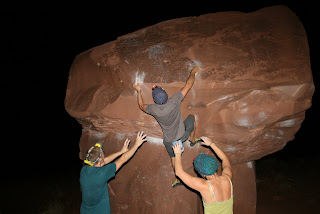
Around two-thirty I'd had enough. At least, I felt a bit more rested, and I was ready to start moving. One other climber was just waking up, and he got the drop on me by about twenty minutes. I followed his headlamp as he climbed. Soon after he was off, I was packed, and climbing diagonally back up towards the ridge on climber's right of Avalanche Gulch. Route finding wasn't difficult, but there were some exposed rock bands that definitely gave me pause up higher - bits of loose rock, and in some cases, a serious lack of snowpack. I climbed carefully. One of my favorite sections of climbing on Shasta is super accessible for everyone! Directly up from Helen Lake to Sargent's - awesome steep climbing, and really fun when the conditions are hard. It is really cool to see climbers headlamped up, moving slowly below you. Eventually I traversed to the upper part of Avalanche Gulch, right around Thumb Rock. Within the hour, more and more headlamps began appearing. Around 12,500 feet, pale blue light was just starting to creep onto the horizon. It was about 4:45 a.m. I counted more than twenty-five headlamps mingling about in the flats of Helen Lake's basecamp, far below. This number would increase, and the steady stream of lights eventually formed a small chain.
I suppose you could claim that you climb Shasta solo, but in reality, unless you're doing a seldom traveled route - Casaval, or more obscure routes on the north side, you're gonna be with people in the later season. In winter you get a bit more solitude. I climbed throughout the night east of Horse Camp, but never had the sensation of being truly alone - whether from the sight of lighted tents, or climbers below me in the gulch, Mt. Shasta has a community sort of feeling to it. Nice people you meet up in the hills sometimes!
By the time I was above Thumb Rock, at about 13,400 feet, the sun was coming up. The orange glow you get up there is so beautiful - so silent, illuminating everything in a glorious panorama. I was about 800 feet shy of the summit when the sun finally crested the side of the ridge - flooding the snowy slopes with glowing light. I stopped for a bit to admire the sight, catch my breath, and have a quick snack (A Clif Bar and Shot Bloks - with a lot of water, they really work well).
I was tired at this point. It's a lot of work to climb all through the night with virtually no sleep. My headache had arrived, and I was even feeling a bit loopy - mix of mild nausea and light of head. But it soon dissipated. Nothing that H20 can't cure!
By 6:40 a.m. I was on the summit plateau, crunching my way over the icy, glowing snow towards the summit pinnacle. I passed two climbers descending as I reached the summit. It was such a gorgeous, clear day! Visibility was awesome, and the sun felt great after an icy, chilly night of climbing. I was on the top for about ten minutes - enough time to shoot a little video panorama and make a phone call, then it was time to head back down.
Unfortunately I was a little bit early on the summit. To my dismay, the snow was still super icy almost the whole way down. This basically meant that glissading was out of the question - it was a long, long downclimb on some icy slopes. I was very happy to eventually reach Helen Lake, from where I could glissade a significant amount towards Horse Camp.
I cut across the valley from Horse Camp, meandering through snowfields and huge bare spots, and eventually ended up at Bunny Flat - right around noon.
All in all, I felt super solid about the climb. I wasn't as fast as I could have been, i'm sure, but I climbed at a fairly consistent pace all night, managed to go really light (pack weighed in just under 28 lbs!), and descended early.
Mt. Shasta cooperated beautifully, and I was very thankful for the weather window and the safe climb.
Conditions right now on Shasta are suprisingly good! There's a good amount of snow coverage all over, and though rock fall and wet avalanches still pose significant danger in the warmer parts of the day, there are plenty of ways to mitigate these risks!
I really do recommend climbing early and descending early. I met groups and groups of climbers on my descent - I was third on the summit at seven, and passed maybe forty people on the way down. The bulk of them weren't going to see the summit before noon. Not that this is especially dangerous, but the potential for rockfall is much greater in the hotter parts of the afternoon. Regardless of not being able to glissade because of the icy slopes, I was very thankful to be out of that bowling alley of a gulch before the heat picked up. So, climb early, descend early - bring plenty of drinking water with you outright - most of all, know when to turn around. The descent takes just as much effort and concentration as does the climb to the top.
Both the upper sections of Casaval and Sargent's ridge are in good condition right now - there is some moderately technical routefinding through rock bands and some exposed sections, but the majority of it is very reasonable for confident and experienced climbers. Below 9,000 feet expect plenty of scree and rock sections - to be quite honest, you don't really need crampons on these sections until higher up. But wear your helmet - you have no idea how many ascending climbers I passed on the way down from the summit with their helmets casually strapped on their packs - you know, between the hours of 9:30 a.m. and 10:30 a.m.
If you bring a helmet, and leave it on your pack. . .
Then you might as well not bring a helmet at all.
And that seems a bit weird, right? Considering Mt. Shasta is renowned for accidents involving falling rock and ice. In fact, when looking up from Lake Helen, you can clearly see track upon track from where large rocks have detached and galumphed merrily along for thousands of vertical feet.
Thus, we can conclude that one should a) bring a climbing helmet, and b) wear said climbing helmet. Love your life, right?
Avalanche gulch is always non-technical, though just as strenuous and demanding as always. In retrospect - climbing Shasta in one day makes for a very, very long day. But it is always worth it, of course. I was exhausted, and swearing somewhere inside that it was the last time I ever did it in one day again without skis, but I was stoked to be up there with such perfect weather and easy climbing conditions. I love alpine climbing in its simplest form - each and every small step it takes to get to the top makes you stronger. It doesn't have to be fun to be fun, right?
I'll probably be headed up tomorrow or next weekend to tackle a different route before the coverage is lost, but until then enjoy the small video mashups Travis created from my footage. In three parts. Doesn't quite do the scale or beauty of that mountain justice, but it may provide some perspective and entertainment. I tend to ramble..
I urge everyone interested to get out on Shasta before the better part of the season comes to an end (two-three weeks max!) - even if just for a climb to Helen Lake, or a hike to Horse Camp. Plenty of wonderful climbers and hikers alike mingling around both locations, and even the view from the valley is worth the drive to Mt. Shasta City.
If you have questions regarding Shasta in whatever capacity, stop in to the shop and pick our brains!
Cheers y'all...
Showing posts with label Ashland Outdoor Store. Show all posts
Showing posts with label Ashland Outdoor Store. Show all posts
Monday, July 12, 2010
Thursday, July 8, 2010
Hot, hot heat
Ooooer!
The heat's got us cookin' this week. It's supposed to be ninety-five degrees today? Chances of thunderstorms, some crazy evening clouds, and plenty of heat to keep you satisfied during the day. I was off in the relative cool of the fairy ponds yesterday evening - enjoying some relax time.
If I didn't have to be at work on weekdays, I'd be out at the coast right now though. Or on the river. Or i'd be up somewhere high, where it's windy (in theory).
I hope everyone had a grand Fourth of July. This weekend was supposed to be adventure weekend on Shasta - however my solo trip was eventually cancelled. In essence, I got persuaded to stick around for the festivities. I slept through the parade, which was wonderful, and enjoyed a leisurely afternoon of BBQ and brews.
Travis enjoyed a leisurely weekend as well - Saturday he rode the Salmon River Loop down in California - 100 miles, starting in Etna, over 10k of vertical! Absolutely beautiful country down there. I was stoked to hear that Travis and team were hitting upwards of 60 mph on the downhills. Get 'em boys.
And this week? Travis, Davi, Bryant, Sarah, Mike and myself have all been hard at work - advising, selling, organizing, consulting, and facilitating. My weekend starts tomorrow! I'm off to Shasta finally to climb Friday and Saturday - about time I made up for my slacking.
Also, I should note that a group of local climbers and myself are heading up to the Greensprings tonight, 6:30 p.m., to meet with some folks from the Mail Tribune - they're doing a story on local climbing. If anyone wants to join, please feel free. We're meeting at the shop, or you can meet at the crag any time after seven!
There will be plenty of adventure coming your way soon - throughout the end of July and most of August! The Trinity Alps, the Sierra Nevada, plenty of backcountry climbing locations, and some awesome road trippin'. Stay tuned - and enjoy the sunshine!
Tuesday, June 29, 2010
The Dance

Now we can finally do the dance!
What dance do you speak of?
The summer dance of course! The grill-is-fired-up and I just-picked-up-some of-that-new-Lagunitas-seasonal-release type of dance. Sort of like funk, but better.
Don't have your summer dance down pat? Or do you feel unsure as to what I'm talking about? I'm sorry, but I can't help you. Summer is a wild time of year - done differently by everyone.
Alright,
So I've noticed in the last two weeks that we're getting an increased amount of inquiries with regards to backpacking in the Marble Mountains Wilderness and Trinity Alps Wilderness. It's definitely that time of year now, but we've got an interesting twist this season that I think everyone should be aware of!
I'd save packing through both Wilderness areas until August and September. Don't get me wrong - they're my favorite areas on almost the entire west coast, with the exception of the Sierra Nevada - but with 140% of normal snowpack this season, most of that extra falling very late, both the bugs and snow are going to be very thick for a while yet. Snow levels are still around 5,000 feet in some areas, meaning that the Forest Service trail crews still have some work to do. I don't know, has anyone else ever been to the Trinity Alps in July? The swarm of biting insects is enough to make it miserable in the evenings. With this much snow, we're not going to be able to climb high enough to escape the bugs until August!
If it were me, I'd pick the Rogue River trail or a Lost Coast trip to tide over the backpacking desire until August/September. The Kalmiopsis Wilderness is also a lovely choice, though the concentration of poison oak is very high. If anyone has any specific questions about any of these locations, come in to the store and pick our brains. They all pretty much allow easy access to water to beat the heat, but with no worries about full Gore-Tex boots and gaiters on a hot day!
Anyways, that's my two cents.
I was at the coast this weekend, as well as the Illinois river, and that water feels great. We're gonna have clear, hot weather all week, and great flow all-around - it's the perfect week for boating or some time at the beach, and also the best week for kicking back with friends on these late evenings. Longest day of the year was the 21st, so don't waste any time!
Have a nice week folks.
Monday, March 8, 2010
Bailey Hut Trip
The Bailey Hut is spoken of in hushed and reverend tones among the backcountry skiing community in the Rogue valley. Surprisingly, there isn't a lot of good beta on the hut and securing a trip can be difficult. You have to call early to get the good dates and it's always a gamble with the winter weather. However, if your trip has good snow conditions and beautiful weather then get ready for some of the best skiing!

Hut Details
Phone: 541.498.2531
Reservation: Open around the 14th or 15th of September every year.
Parking: Park at the Three Lakes Trail Snow Park
Skin in: budget for 2.5 hours
Cabin: Three story A-Frame. Second and Third floors are for sleeping and main level is for cooking and hanging out by the fireplace. There is a bathroom! It is located off the back side of the main floor. Bring your own TP!

Kitchen: There is a table to cook on and a couple big pots for melting water on the fireplace. Bring your own stove, cookware, and food.
Bailey Hut 360 from Travis Caldwell on Vimeo.


Lighting: You can burn candles on the main floor, but a good lantern goes a long long ways.
Firewood: The cabin is stocked with firewood, but funding is low and if you have the ability to bring in your own firewood it is a tremendous help.
Drive Time: From Ashland head North on I5. Take the Crater Lake exit and get onto Crater Lake highway. Stay on Crater lake highway until it turns into hwy 230. Continue on hwy 230 until you reach the Three Lakes Trail snow park. The snow park will be on your left. The drive will take approximately 2hrs as long as the roads are clear. If there is bad weather allocate more time for driving there.

Trail: Take the cat-track from the parking lot for a couple miles and take a right (towards Diamond Lake) at the first intersection you come to. Within the first couple hundred yards the trail to the cabin starts up on the left. This portion of the trail is non-groomed and the only tracks are from previous skiers.


Summiting: The summit is roughly a three hours skin from the hut. There are a couple of routes to the summit. You can go straight from the hut up the ridge, or you can make your way to the bowl on the east side and then up through the heart of the bowl to the summit. Both options are within minutes of each other to the summit.
Don't Forgets (besides all your AVI gear): Sun Block, Chap-stick, Lantern, Cards and or other games to kill the time in the hut. A GPS is a great tool to have on this trip!
 East Face Bowl on Mount Bailey
You could ski Mount Bailey for weeks straight and still not explore all the lines it has to offer. There are some very tight shoots and rock bands to drop for advanced riders, but there are also mellower that are easily skied by someone in the intermediate ability range.
 View of Mount Thielsen
Snowmachines are allowed on the cat track and other designated area's on the mountain. They are not allowed on the trail to the hut, so getting your food and supplies into the hut is all man/women powered. Sleds are a nice way to carry a lot of stuff, but they get heavy, so be sure to take turns cause you don't want to wear yourself out before you start the skiing.
If you have any questions about your upcoming trip to mount bailey that was not addressed here please feel free to call, 541.488.1202, or email Websales!
Wednesday, January 6, 2010
Please Insert Adventure Here
If there is one thing an injury does its provide you with down time. If there is one thing that couch time provides is an opportunity for the imagination to do it's thing. If there is one thing that I do well it's think up big imaginative schemes and ideas. My idea's around adventures usually get crazier with every passing day that I don't get my adventure fix. Therefore, I think it may be needless to say, but 2010 is going to be full of epic trips.
Here is just a taste of the type of stuff that we will be doing: Attempting a Ski Mountaineering trip to summit six Cascade peaks in six days, attempting to kayak from the plaza in Ashland to the Pacific Ocean, go rafting in at least two new countries even if they are neighboring ones, winter approach multi-pitch climbing, and a spattering of other expadentures such as local adventure running, climbing, skiing, biking, and boating trips.
The other effort that will be made this year in our adventure posts is more details on how we pulled off the trip along with beta on where to stay, shop, eat, and etc. There will also be more photo documentation of the trips and hopefully good video too.
So please stay tuned and if you have any ideas for a cool adventure let us know.
Wednesday, December 23, 2009
Smith River Gorges
A couple weekends ago I awoke to 20 degree temperature and and ice/frost combo on the ground. I decided to do the most logical thing, GO BOATING!
There was four of us going (myself, Dan, Frank, and Chris), so we took an 11.5" raft to r3 and then a creek boat kayak for the 4th. We weren't sure what to expect from the gorges because the flows were quite a bit lower (500cfs in the Middle Fork) then we would have liked. But it didn't prevent us from making a day of it.
We ran the Middle Fork first. Because the flow was so low some of the rapids were a bit tighter and steeper making them really fun. The continuos 1.5 mile run went really fast! We ran the South Fork Gorge second, and it was even lower flow so it was even tighter and steeper and faster. We had good clean lines, no swimmers, no carnage, and a lot of cold water winter boating fun.
The Smith River is by far one of the most gorgeous river's in our area. The combination of the clear water, the california warmth, and the redwoods is unbeatable, and if you time it right you can see some massive Salmon. The easy road-side access also makes logistics a breeze for shuttling and doing multiple runs in the same day. There is also a lot of variety in the difficulty level which can accommodate all skill and comfort levels.
There are a lot of different write ups out there about the Smith, but here are our favorites: California Creek's, and Oregon Rafting.

Frankie taking his sweet time!
There was four of us going (myself, Dan, Frank, and Chris), so we took an 11.5" raft to r3 and then a creek boat kayak for the 4th. We weren't sure what to expect from the gorges because the flows were quite a bit lower (500cfs in the Middle Fork) then we would have liked. But it didn't prevent us from making a day of it.
We ran the Middle Fork first. Because the flow was so low some of the rapids were a bit tighter and steeper making them really fun. The continuos 1.5 mile run went really fast! We ran the South Fork Gorge second, and it was even lower flow so it was even tighter and steeper and faster. We had good clean lines, no swimmers, no carnage, and a lot of cold water winter boating fun.

Oregon Hole
Photo Credit: Will Volpert
The Smith River is by far one of the most gorgeous river's in our area. The combination of the clear water, the california warmth, and the redwoods is unbeatable, and if you time it right you can see some massive Salmon. The easy road-side access also makes logistics a breeze for shuttling and doing multiple runs in the same day. There is also a lot of variety in the difficulty level which can accommodate all skill and comfort levels.

Dan somewhere in the South Fork
Photo Credit: Will Volpert
There are a lot of different write ups out there about the Smith, but here are our favorites: California Creek's, and Oregon Rafting.
Thursday, October 29, 2009
Moab Utah
Meca: "The biggest, best thing. The most mega." (Urban Dictionary) There are few locations that can truly be described as the meca for their sport. Moab is one of those location, and is most definitely the rock climbing meca.


The reddish colored sandstone walls and towers loom in the distance as you approach, and they only get bigger, bigger, and bigger. There is an endless amount of climbing to be done, so be prepared and don't let it overwhelm you.


My recommendation for camping is to take a left on Hwy 128 just after you cross the Colorado on your way into Moab. Roughly 7 miles up the road will be Big Bend Campground. It is a BLM maintained camp ground and is very nice as well as reasonably priced $10/night. It is conveniently located in the middle of the majority of climbing locations. Castleton Tower is about 10 miles further up the river, and Wall Street is about 10 miles the other direction. The added bonus to Big Bend Campground is the bouldering (Big Bend Boulders in the guide books) is right across the street. Big Bend Boulders is a phenomenal place to bolder and following suite to all of Moab has some very challenging routes.


For climbing there isn't a much cooler place the Wall Street (aka Potash Road). It also offers an assortment of climbing level's including a few top-rope options. All the belaying could be done from the roof of you Winnebago with the tunes bumping. Just make sure you don't deck out on the hood. Beyond Wall Street, if you can climb 5.12 and have a lot of gear then you will be in heaven because the options are almost endless and only stifled by your physical ability and gear budget.


Water! It is the dessert after all, so you will need and consume a lot of water. There is a natural spring on the right hand side of the Hwy 128 when you turn off for Big Bend. It's the water that all the outfitters and who's-who's use. Drink at your own risk and if your paranoid filter it.

While your in town there is a nice laundromat, grocery store, and hostel (lazy lizard) if you don't want to camp. Also, be sure to go into Pagan Mountaineering while your there. The staff is a great resource, and they carry some pretty cool stuff too.

Whatever you do, do not poach camping. The area is patrolled heavily, and they will issue you or your group a ticket. Which, speaking from experience, is not the best way to start your morning.


The reddish colored sandstone walls and towers loom in the distance as you approach, and they only get bigger, bigger, and bigger. There is an endless amount of climbing to be done, so be prepared and don't let it overwhelm you.

My recommendation for camping is to take a left on Hwy 128 just after you cross the Colorado on your way into Moab. Roughly 7 miles up the road will be Big Bend Campground. It is a BLM maintained camp ground and is very nice as well as reasonably priced $10/night. It is conveniently located in the middle of the majority of climbing locations. Castleton Tower is about 10 miles further up the river, and Wall Street is about 10 miles the other direction. The added bonus to Big Bend Campground is the bouldering (Big Bend Boulders in the guide books) is right across the street. Big Bend Boulders is a phenomenal place to bolder and following suite to all of Moab has some very challenging routes.


For climbing there isn't a much cooler place the Wall Street (aka Potash Road). It also offers an assortment of climbing level's including a few top-rope options. All the belaying could be done from the roof of you Winnebago with the tunes bumping. Just make sure you don't deck out on the hood. Beyond Wall Street, if you can climb 5.12 and have a lot of gear then you will be in heaven because the options are almost endless and only stifled by your physical ability and gear budget.


Water! It is the dessert after all, so you will need and consume a lot of water. There is a natural spring on the right hand side of the Hwy 128 when you turn off for Big Bend. It's the water that all the outfitters and who's-who's use. Drink at your own risk and if your paranoid filter it.

While your in town there is a nice laundromat, grocery store, and hostel (lazy lizard) if you don't want to camp. Also, be sure to go into Pagan Mountaineering while your there. The staff is a great resource, and they carry some pretty cool stuff too.

Whatever you do, do not poach camping. The area is patrolled heavily, and they will issue you or your group a ticket. Which, speaking from experience, is not the best way to start your morning.

Thursday, September 10, 2009
Expadentures at Altivation on Lamorial Day Weekend
I live by several philosophies. One of the main philosophies is that the last weekend of summer has to be epic! Okay, so that isn't actually a philosophy that I live by, but I did decide this year that I wanted to cap off summer and launch into fall with a good solid adventure filled weekend. As the weekend drew closer I was getting very nervous about the likelihood of any adventure happening because flow's were down, people were out, and weather was getting bad. But we rolled with the punches and kept the adventure weekend alive. Since funding for the weekend was tight we had to come up with idea's that were not going to break the bank, and since not everyone had a four day weekend we had to stay fairly close to home.
Day 1 - Friday
We started off the weekend with a fun and easy float down on the Klamath River. The section is known as the Tree of Heaven run. It is a solid class II run with arguably the best play wave around thrown in for good measure. While it doesn't offer much in the way of excitement, it does offer a relaxing day on the water and in the sun. You know this because it is always sunny in California. We brought a 12' raft and frame and a playboat kayak. We used the raft, but strapped the kayak down as a stern ornament for the day. We had a couple good attempts at surfing the raft in the playwave and a good lunch/dinner along the bank.

(It was later that we found out that there was an algae bloom warning for this section and it was being advised to not have contact with the water)

As we drove back north through Ashland Frank jumped out of the car and Wrenna and I continued on to the North Fork of the Rogue River near Union Creek. We crept/snuck into the Abbot Creek Camp Ground a little after midnight and quickly setup our tent and crawled inside.

Day 2 - Saturday
We awoke and maintained a leisurely morning eating oatmeal and slacklining, and then we were off to Mount Thielsen. From where we were camped Thielsen was a short 45-minute drive. Early on into the hike we could see a weather system moving towards the mountain, and a fair number of hikers heading the opposite direction we were. However, we continued to push on through, and as we reached the tree line we were embraced by the wind and rain that had been scaring everyone else away. Not to be deterred by mother-nature we dawned our rain wear and pushed on.


Once we reached an upper section of the ridge where the coverage was non-existent we sat with our faces turned into the wind and felt the rain and wind prickle our faces until we were good and cold. Being content with embracing mother-nature we headed down off the ridge. On the descent I realized that I have no grasp for time or distance when it comes to hiking. I was shocked at how long it took us to get back to the trailhead. Also, not having done much hiking all summer long, my feet and legs were very happy to be back to the car and back in my Chaco's. By the time we got back to camp we had enough time to cook some food and collect firewood. I think that campfire might be my favorite part of camping (side note: I hate the word camping and you will probably read a blog post soon about that).


Day 3 - Sunday
Seeing as breakfast is the most important meal of the day we again took our time eating more oatmeal and doing some more slacklining before heading out to Mount McLoughlin. Driving to the trail head took longer then estimated because the obvious directions weren't so obvious. Once you are on the gravel road continue straight to the parking lot. Do not take the right turn that says McLoughlin Trail.


McLoughlin is a sweet hike. The trail doesn’t stay flat for very long and becomes rather steep quickly. The forest is really beautiful, and once we got above the tree line the views became spectacular. I was really shocked at how far we hiked before we reached the tree line. From the road McLoughlin deceivingly looks bare. Unfortunately, for a second day the weather was not very cooperative. The storm from the day before deposited ice on the summit, so combining that with high winds, cold temperature, and waning sun we had to forgo the summit on day two as well.


The descent was quick and a bit painful do to the steepness and our legs being tired from the previous day’s hike. We jammed it out and headed back into Ashland for a quick presentation for isBreathing , reloaded, refueled, and picking up Frank. We were back out at camp before we new it enjoying the campfire and the evenings dessert.

Day 4 - Sunday
Unfortunately, we slept through our put-on time we had planed with Bryant and Johannah, so to make up for it we ate. We cooked up a big egg scramble cooked over the open flame and then took down camp and headed to the put in for the River Bridge section of the Rogue River.


The day was hot, but the water was, as always, super cold. So at the heat of the day we inflated the raft, rode the bike shuttle, and dawned our dry suits. River Bridge is currently sitting at the top of my favorites list for a day run. The rapids are technical drops but low consequence and the scenery is beautiful and offer solitude. This time of year the flow is pretty low which made for a bumpy and boney ride. We encountered a couple logs in the river that couldn’t be avoided and required us to line the boat around them. There were a lot of moves that had to be made in this 5-mile stretch of river and all of them were tight. Frank and Wrenna were awesome bow paddlers and got really good at bouncing off of rocks and down the river. By the time we hit the reservoir at the end of the run I had sweated close to my body weight into my (aka Franks) drytop, so I let the other two row the rest of the way and I relaxed and started re-hydrating. The drive back to Ashland was a quiet one, and not because excitement wasn’t filling our bones, but because exhaustion was more set in.


I have to say that Labor Day weekend 09 was on of the best weekends I have had all summer and was just some good old fashion adventuring! It definitely was inspiring and rejuvenating. Plus, it gave me time to plot and work angles for more adventures to come.
We want to give a special thanks to the SOU Outdoor Program for the use of the raft, and to The Ashland Outdoor Store for a long weekend.
Thursday, August 20, 2009
Lost Rocks

It has been a couple years since I have been to lost rocks, but I've come across some pictures rescently of that trip and it has inspired me to head back there. The lost rocks bouldering area is currently my favorite bouldering location.

It is located on the Northern (when I say Northern I mean as far north as you can get) coast of California. Driving from Ashland you head to Crescent City and then south along the coast. Drive until you get to a bridge that has golden bears on each side of the bridge and then take the next exit. At the stop sign take a left. Rhere is a car camping option if you want hookups, bathrooms, and water. This option isn't expensive but not exactly cheap either. If you are going the cheap route there is a free spot to camp. Follow the road until it turns to gravel and then roughly 1/2 mile later on the right there is a turnout, and that is where you can camp for free.

Just before the road turns to gravel it takes a 90 degree turn to the left. At the apex of the corner there is a driveway and a gate. This driveway (while can be an access to the beach and climbing) is also part of a Native American holy ground. In the past there has been issue's between the Native American's and climbers because the climbers have used/misused this area to get to the bouldering on the beach. It is my current understanding that the tension has been resolved, but please be respectful, and my recommendation is to use the alternative access to the beach.

The alternative access is further up the road from the free camp spot. There is an official lookout complete with a bathroom. At the lookout there is a trail head. Depending on the time of year and how frequently the trail has been used it can be fairly or excessively overgrown so be prepared.

Once you are down on the beach there is a lot of climbing. I still use a crash pad but many don't because the sand is soft for landing. However, there are a couple highballerish problems that I have fallen from and have been very happy to have my crash pad upon impact. If you feel like hauling a rope and your sport climbing rack with you there is a ridiculously hard rope route that is hidden and you have to find it. Personally, I don't think it is worth it but now you know it's there and is an option if you can find it.


There is a new book out Northern California Bouldering by Chris Summit and crew that has some info on the boulder problems. And, so far it is the best printed resource that I know of for the area. I would recommend making a weekend trip out of your visit to Lost Rocks. A good two to three days provides you with enough time to fully explore and not get bored. If you have time on the drive there during the summer time there are a lot of good swimming holes along the Smith river that offer a refreshing break.

Don't forget your binoculars because there is some really good whale watching spots. Also, it's the coast so be prepared for cool weather, and remember that you are climbing in a very dynamic area so don't forget about the tides changing.
Subscribe to:
Posts (Atom)

