AOS Adventures

Wednesday, December 23, 2009

Smith River Gorges

A couple weekends ago I awoke to 20 degree temperature and and ice/frost combo on the ground. I decided to do the most logical thing, GO BOATING!


Frankie taking his sweet time!


There was four of us going (myself, Dan, Frank, and Chris), so we took an 11.5" raft to r3 and then a creek boat kayak for the 4th. We weren't sure what to expect from the gorges because the flows were quite a bit lower (500cfs in the Middle Fork) then we would have liked. But it didn't prevent us from making a day of it.

We ran the Middle Fork first. Because the flow was so low some of the rapids were a bit tighter and steeper making them really fun. The continuos 1.5 mile run went really fast! We ran the South Fork Gorge second, and it was even lower flow so it was even tighter and steeper and faster. We had good clean lines, no swimmers, no carnage, and a lot of cold water winter boating fun.


Oregon Hole
Photo Credit: Will Volpert


The Smith River is by far one of the most gorgeous river's in our area. The combination of the clear water, the california warmth, and the redwoods is unbeatable, and if you time it right you can see some massive Salmon. The easy road-side access also makes logistics a breeze for shuttling and doing multiple runs in the same day. There is also a lot of variety in the difficulty level which can accommodate all skill and comfort levels.


Dan somewhere in the South Fork
Photo Credit: Will Volpert


There are a lot of different write ups out there about the Smith, but here are our favorites: California Creek's, and Oregon Rafting.

Thursday, October 29, 2009

Moab Utah

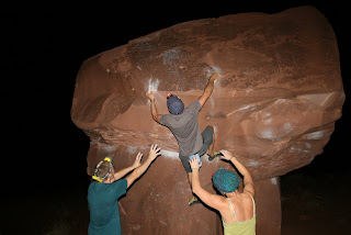
Meca: "The biggest, best thing. The most mega." (Urban Dictionary) There are few locations that can truly be described as the meca for their sport. Moab is one of those location, and is most definitely the rock climbing meca.


The reddish colored sandstone walls and towers loom in the distance as you approach, and they only get bigger, bigger, and bigger. There is an endless amount of climbing to be done, so be prepared and don't let it overwhelm you.


My recommendation for camping is to take a left on Hwy 128 just after you cross the Colorado on your way into Moab. Roughly 7 miles up the road will be Big Bend Campground. It is a BLM maintained camp ground and is very nice as well as reasonably priced $10/night. It is conveniently located in the middle of the majority of climbing locations. Castleton Tower is about 10 miles further up the river, and Wall Street is about 10 miles the other direction. The added bonus to Big Bend Campground is the bouldering (Big Bend Boulders in the guide books) is right across the street. Big Bend Boulders is a phenomenal place to bolder and following suite to all of Moab has some very challenging routes.


For climbing there isn't a much cooler place the Wall Street (aka Potash Road). It also offers an assortment of climbing level's including a few top-rope options. All the belaying could be done from the roof of you Winnebago with the tunes bumping. Just make sure you don't deck out on the hood. Beyond Wall Street, if you can climb 5.12 and have a lot of gear then you will be in heaven because the options are almost endless and only stifled by your physical ability and gear budget.


Water! It is the dessert after all, so you will need and consume a lot of water. There is a natural spring on the right hand side of the Hwy 128 when you turn off for Big Bend. It's the water that all the outfitters and who's-who's use. Drink at your own risk and if your paranoid filter it.


While your in town there is a nice laundromat, grocery store, and hostel (lazy lizard) if you don't want to camp. Also, be sure to go into Pagan Mountaineering while your there. The staff is a great resource, and they carry some pretty cool stuff too.


Whatever you do, do not poach camping. The area is patrolled heavily, and they will issue you or your group a ticket. Which, speaking from experience, is not the best way to start your morning.

Friday, October 2, 2009

Lost Rocks

Stemming from the inspiration of my last post about Lost Rocks and the fact that I hadn't been there in a couple years a crew of us adventured back to the epic land of boulders. There is something completely awesome about climbing on the beach. I don't know if it is the salt in the air, the gigantic waves crashing on the beach, rotting sea life carcasses, or the insanely good bouldering problems that makes this my favorite bouldering spot.


This trip we ended up camping in a turnout the first night. It was a perfect little campsite, and we quickly worked through setting up and eating so we could get some rest. We were up early so again we made quick work of eating and tearing down camp. We were hiking into the bouldering area by 9 am.


There beach has changed a lot in the 3 years since I was there, and a problem that I had been eager to work on again was no longer climbable. Which was a little disappointing, but also forced me to explore more climbs. We climbed hard for the morning and around lunch time decided to hike out so we could eat and get our camping equipment and camp on the beach.


Night two was an awesome night camping right on the beach, watching the sunset, playing card games, campfire, and meeting new friends. We were not moving nearly as quickly the next morning though. The long day left us stiff and tired. After slowly getting out of our sleeping bags, eating breakfast, and stretching we set out for some more climbing. One route in particular that Mimi and I had been working on was at the top of the list.


After making quick work of the problem that had eluded us the day before we decided to leave on a high note. Milkshakes were on our minds and we stopped as quickly as we could to indulge cravings. We ended up gorging ourselves before waddling back into the car and voyaging home. Luckily we made it home just in time for dinner!


A few lagistical updates: #1 The drive from Ashland takes almost exactly 3 hours no matter how you roll the dice. #2 The turnout on the right that has the trail head is the Flint Ridge Trail head. The Flint Ridge trail is on the left of the road, follow the trail down the beach. #3 Wear proper shoes. Fling hike in and scramble along the beach will be made much easier with a good pair of approach shoes.

Thursday, September 10, 2009

Expadentures at Altivation on Lamorial Day Weekend

I live by several philosophies. One of the main philosophies is that the last weekend of summer has to be epic! Okay, so that isn't actually a philosophy that I live by, but I did decide this year that I wanted to cap off summer and launch into fall with a good solid adventure filled weekend. As the weekend drew closer I was getting very nervous about the likelihood of any adventure happening because flow's were down, people were out, and weather was getting bad. But we rolled with the punches and kept the adventure weekend alive. Since funding for the weekend was tight we had to come up with idea's that were not going to break the bank, and since not everyone had a four day weekend we had to stay fairly close to home.

Day 1 - Friday
We started off the weekend with a fun and easy float down on the Klamath River. The section is known as the Tree of Heaven run. It is a solid class II run with arguably the best play wave around thrown in for good measure. While it doesn't offer much in the way of excitement, it does offer a relaxing day on the water and in the sun. You know this because it is always sunny in California. We brought a 12' raft and frame and a playboat kayak. We used the raft, but strapped the kayak down as a stern ornament for the day. We had a couple good attempts at surfing the raft in the playwave and a good lunch/dinner along the bank.


(It was later that we found out that there was an algae bloom warning for this section and it was being advised to not have contact with the water)


As we drove back north through Ashland Frank jumped out of the car and Wrenna and I continued on to the North Fork of the Rogue River near Union Creek. We crept/snuck into the Abbot Creek Camp Ground a little after midnight and quickly setup our tent and crawled inside.


Day 2 - Saturday
We awoke and maintained a leisurely morning eating oatmeal and slacklining, and then we were off to Mount Thielsen. From where we were camped Thielsen was a short 45-minute drive. Early on into the hike we could see a weather system moving towards the mountain, and a fair number of hikers heading the opposite direction we were. However, we continued to push on through, and as we reached the tree line we were embraced by the wind and rain that had been scaring everyone else away. Not to be deterred by mother-nature we dawned our rain wear and pushed on.


Once we reached an upper section of the ridge where the coverage was non-existent we sat with our faces turned into the wind and felt the rain and wind prickle our faces until we were good and cold. Being content with embracing mother-nature we headed down off the ridge. On the descent I realized that I have no grasp for time or distance when it comes to hiking. I was shocked at how long it took us to get back to the trailhead. Also, not having done much hiking all summer long, my feet and legs were very happy to be back to the car and back in my Chaco's. By the time we got back to camp we had enough time to cook some food and collect firewood. I think that campfire might be my favorite part of camping (side note: I hate the word camping and you will probably read a blog post soon about that).


Day 3 - Sunday
Seeing as breakfast is the most important meal of the day we again took our time eating more oatmeal and doing some more slacklining before heading out to Mount McLoughlin. Driving to the trail head took longer then estimated because the obvious directions weren't so obvious. Once you are on the gravel road continue straight to the parking lot. Do not take the right turn that says McLoughlin Trail.


McLoughlin is a sweet hike. The trail doesn’t stay flat for very long and becomes rather steep quickly. The forest is really beautiful, and once we got above the tree line the views became spectacular. I was really shocked at how far we hiked before we reached the tree line. From the road McLoughlin deceivingly looks bare. Unfortunately, for a second day the weather was not very cooperative. The storm from the day before deposited ice on the summit, so combining that with high winds, cold temperature, and waning sun we had to forgo the summit on day two as well.


The descent was quick and a bit painful do to the steepness and our legs being tired from the previous day’s hike. We jammed it out and headed back into Ashland for a quick presentation for isBreathing , reloaded, refueled, and picking up Frank. We were back out at camp before we new it enjoying the campfire and the evenings dessert.


Day 4 - Sunday
Unfortunately, we slept through our put-on time we had planed with Bryant and Johannah, so to make up for it we ate. We cooked up a big egg scramble cooked over the open flame and then took down camp and headed to the put in for the River Bridge section of the Rogue River.


The day was hot, but the water was, as always, super cold. So at the heat of the day we inflated the raft, rode the bike shuttle, and dawned our dry suits. River Bridge is currently sitting at the top of my favorites list for a day run. The rapids are technical drops but low consequence and the scenery is beautiful and offer solitude. This time of year the flow is pretty low which made for a bumpy and boney ride. We encountered a couple logs in the river that couldn’t be avoided and required us to line the boat around them. There were a lot of moves that had to be made in this 5-mile stretch of river and all of them were tight. Frank and Wrenna were awesome bow paddlers and got really good at bouncing off of rocks and down the river. By the time we hit the reservoir at the end of the run I had sweated close to my body weight into my (aka Franks) drytop, so I let the other two row the rest of the way and I relaxed and started re-hydrating. The drive back to Ashland was a quiet one, and not because excitement wasn’t filling our bones, but because exhaustion was more set in.


I have to say that Labor Day weekend 09 was on of the best weekends I have had all summer and was just some good old fashion adventuring! It definitely was inspiring and rejuvenating. Plus, it gave me time to plot and work angles for more adventures to come.

We want to give a special thanks to the SOU Outdoor Program for the use of the raft, and to The Ashland Outdoor Store for a long weekend.

Thursday, August 20, 2009

Lost Rocks


It has been a couple years since I have been to lost rocks, but I've come across some pictures rescently of that trip and it has inspired me to head back there. The lost rocks bouldering area is currently my favorite bouldering location.


It is located on the Northern (when I say Northern I mean as far north as you can get) coast of California. Driving from Ashland you head to Crescent City and then south along the coast. Drive until you get to a bridge that has golden bears on each side of the bridge and then take the next exit. At the stop sign take a left. Rhere is a car camping option if you want hookups, bathrooms, and water. This option isn't expensive but not exactly cheap either. If you are going the cheap route there is a free spot to camp. Follow the road until it turns to gravel and then roughly 1/2 mile later on the right there is a turnout, and that is where you can camp for free.


Just before the road turns to gravel it takes a 90 degree turn to the left. At the apex of the corner there is a driveway and a gate. This driveway (while can be an access to the beach and climbing) is also part of a Native American holy ground. In the past there has been issue's between the Native American's and climbers because the climbers have used/misused this area to get to the bouldering on the beach. It is my current understanding that the tension has been resolved, but please be respectful, and my recommendation is to use the alternative access to the beach.


The alternative access is further up the road from the free camp spot. There is an official lookout complete with a bathroom. At the lookout there is a trail head. Depending on the time of year and how frequently the trail has been used it can be fairly or excessively overgrown so be prepared.


Once you are down on the beach there is a lot of climbing. I still use a crash pad but many don't because the sand is soft for landing. However, there are a couple highballerish problems that I have fallen from and have been very happy to have my crash pad upon impact. If you feel like hauling a rope and your sport climbing rack with you there is a ridiculously hard rope route that is hidden and you have to find it. Personally, I don't think it is worth it but now you know it's there and is an option if you can find it.


There is a new book out Northern California Bouldering by Chris Summit and crew that has some info on the boulder problems. And, so far it is the best printed resource that I know of for the area. I would recommend making a weekend trip out of your visit to Lost Rocks. A good two to three days provides you with enough time to fully explore and not get bored. If you have time on the drive there during the summer time there are a lot of good swimming holes along the Smith river that offer a refreshing break.


Don't forget your binoculars because there is some really good whale watching spots. Also, it's the coast so be prepared for cool weather, and remember that you are climbing in a very dynamic area so don't forget about the tides changing.